

Category of Astronomical Heritage: tangible immovable
Taosi observatory, China
Format: Short Description (ICOMOS-IAU Case Study format)
Presentation
Geographical position
Xiangfen County, Shanxi province, China
Location
Latitude 35° 52′ 55.9″ N, longitude 111° 29′ 54.9″ E. Elevation 573m above mean sea level.
General description
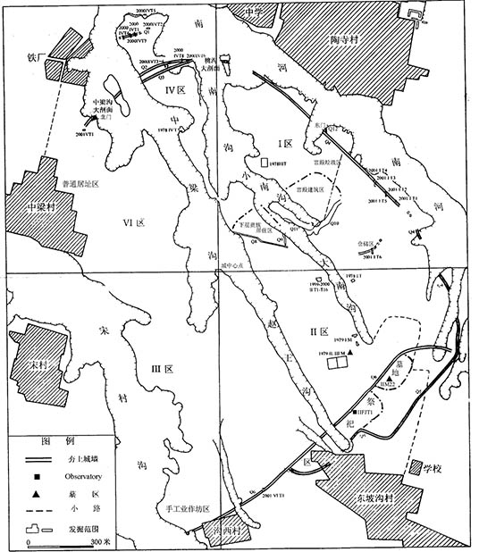
Fig. 1. Location of Taosi Observatory (identified as feature IIFJT1) within the Taosi site. After He Nu and Shanxi Xiangfen (2009), ’Taosi chengzhi zhongqi wang ji da mu IIM22 chutu qigan guichi gongneng shitan [On the gnomon shadow template function of the lacquer stick from the royal tomb IIM22 at Taosi walled-town of Middle Period]‘, Ziran kexueshi yanjiu [Studies in the history of natural sciences], 28(3), 261-276
Taosi ancient observatory forms part of the Taosi archaeological site, one of the most famous of the eighty or so Longshan Culture (c. 3000-2000 BC) sites in north China. At the Taosi site, a small walled-town of the Early Taosi Period (23rd and 22nd centuries BC) was superseded by two walled-towns of the Middle Period (21st century BC), the larger of which occupied 2.8km² and is the largest known walled-town in prehistoric China. The observatory is located within the lesser Middle Period walled-town, close to the inner south-eastern wall of the larger one.
Brief inventory
A semi-circular platform about 1,000m² in area, measuring 40m across from east to west and about 29m from north to south, appears to have consisted of three concentric terraces. The innermost, with a radius of about 21m, has a rammed-earth retaining wall 22.5m long, 1.1m wide and 2.7m high, which contains a series of eleven rammed-earth pillars arranged along the arc. These were formed by cutting ten U- or V-shaped slots into the top of the wallfoundation, which survive to a depth of about 4-17 cm and are filled with soft earth. Most are 15-20 cm in width, the southernmost two being slightly wider. A rammed-earth block on the second terrace has been slotted in a similar manner, to form two further pillars.
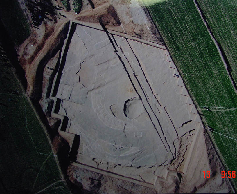
Fig. 2. Aerial view of the observatory. North is to the right. Photograph © He Nu
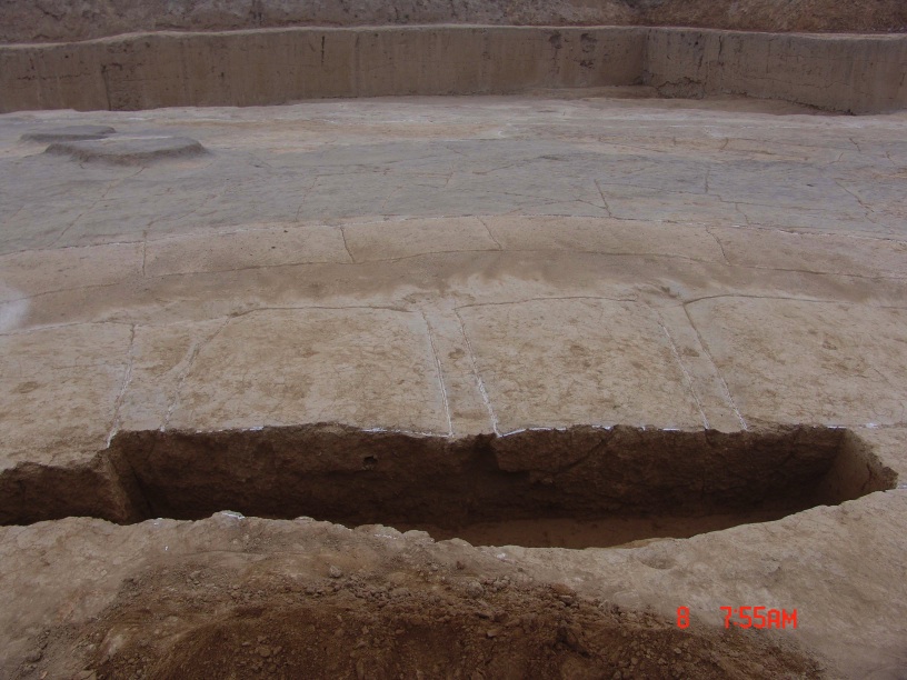
Fig. 3. Foundations of the pillars and slots. Photograph © He Nu
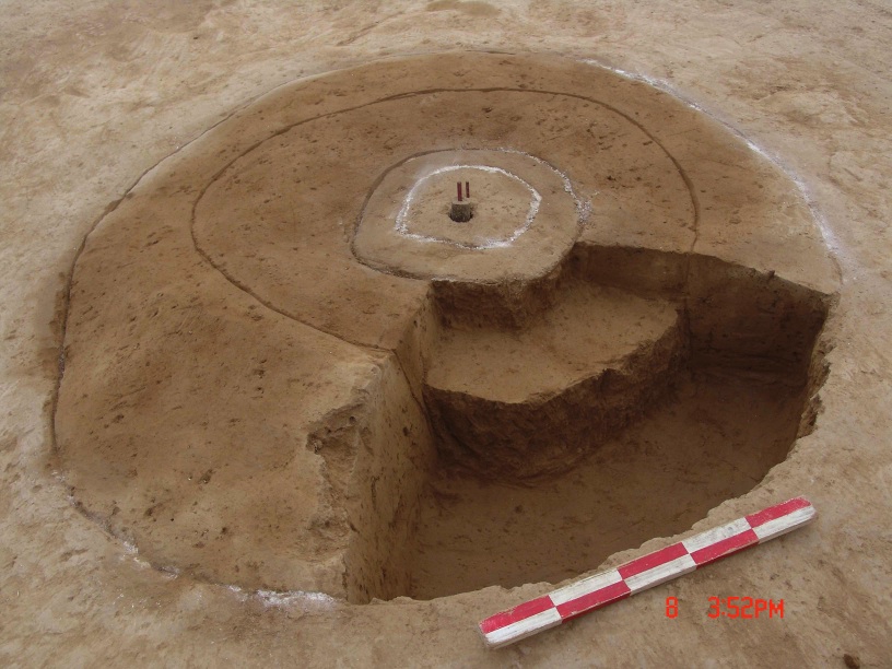
Fig. 4. The observation point. Photograph © He Nu
Slightly to the west of the geometrical centre of the platform archaeologists have found a round foundation-pit and three concentric rammed-earth circles. As viewed from this point, the series of 11 pillars with 10 slots on the third terrace and the 2 pillars with 1 slot on the second terrace appeared to form a single line of 13 pillars and 12 slots (the gap between the south pillar on the second terrace and the north pillar on the third terrace forming the additional slot) against the skyline formed by Taer Hill, or Chong Hill, a prominent chain of peaks (up to 1493m in elevation) about 7 to 10km to the east.
Calculations and experimental observations indicate that 4000 years ago the sun would have risen in the northernmost slot at the June solstice, and in the slot next to the southernmost at the December solstice. Slot no. 7 (counting from south to north) could possibly have been used to determine the spring and autumn equinoxes: nowadays the sun can be seen as rising in this slot on March 18 and September 25. The southernmost slot could not have been used to observe sunrise, although it did indicate the position of southernmost (‘major standstill’) moonrise.
The fact that a clear archaeological structure has been discovered at the point where the centre-lines of the 12 slots converge implies that the twelve slots and the observation point must have been designed carefully and formed an integrated observation system.
History
Xiangfen County, Shanxi province, China
Location
Latitude 35° 52′ 55.9″ N, longitude 111° 29′ 54.9″ E. Elevation 573m above mean sea level.
General description
Fig. 1. Location of Taosi Observatory (identified as feature IIFJT1) within the Taosi site. After He Nu and Shanxi Xiangfen (2009), ’Taosi chengzhi zhongqi wang ji da mu IIM22 chutu qigan guichi gongneng shitan [On the gnomon shadow template function of the lacquer stick from the royal tomb IIM22 at Taosi walled-town of Middle Period]‘, Ziran kexueshi yanjiu [Studies in the history of natural sciences], 28(3), 261-276
Taosi ancient observatory forms part of the Taosi archaeological site, one of the most famous of the eighty or so Longshan Culture (c. 3000-2000 BC) sites in north China. At the Taosi site, a small walled-town of the Early Taosi Period (23rd and 22nd centuries BC) was superseded by two walled-towns of the Middle Period (21st century BC), the larger of which occupied 2.8km² and is the largest known walled-town in prehistoric China. The observatory is located within the lesser Middle Period walled-town, close to the inner south-eastern wall of the larger one.
Brief inventory
A semi-circular platform about 1,000m² in area, measuring 40m across from east to west and about 29m from north to south, appears to have consisted of three concentric terraces. The innermost, with a radius of about 21m, has a rammed-earth retaining wall 22.5m long, 1.1m wide and 2.7m high, which contains a series of eleven rammed-earth pillars arranged along the arc. These were formed by cutting ten U- or V-shaped slots into the top of the wallfoundation, which survive to a depth of about 4-17 cm and are filled with soft earth. Most are 15-20 cm in width, the southernmost two being slightly wider. A rammed-earth block on the second terrace has been slotted in a similar manner, to form two further pillars.
Fig. 2. Aerial view of the observatory. North is to the right. Photograph © He Nu
Fig. 3. Foundations of the pillars and slots. Photograph © He Nu
Fig. 4. The observation point. Photograph © He Nu
Slightly to the west of the geometrical centre of the platform archaeologists have found a round foundation-pit and three concentric rammed-earth circles. As viewed from this point, the series of 11 pillars with 10 slots on the third terrace and the 2 pillars with 1 slot on the second terrace appeared to form a single line of 13 pillars and 12 slots (the gap between the south pillar on the second terrace and the north pillar on the third terrace forming the additional slot) against the skyline formed by Taer Hill, or Chong Hill, a prominent chain of peaks (up to 1493m in elevation) about 7 to 10km to the east.
Calculations and experimental observations indicate that 4000 years ago the sun would have risen in the northernmost slot at the June solstice, and in the slot next to the southernmost at the December solstice. Slot no. 7 (counting from south to north) could possibly have been used to determine the spring and autumn equinoxes: nowadays the sun can be seen as rising in this slot on March 18 and September 25. The southernmost slot could not have been used to observe sunrise, although it did indicate the position of southernmost (‘major standstill’) moonrise.
The fact that a clear archaeological structure has been discovered at the point where the centre-lines of the 12 slots converge implies that the twelve slots and the observation point must have been designed carefully and formed an integrated observation system.
History
A semi-circular platform about 1,000m² in area, measuring 40m across from east to west and about 29m from north to south, appears to have consisted of three concentric terraces. The innermost, with a radius of about 21m, has a rammed-earth retaining wall 22.5m long, 1.1m wide and 2.7m high, which contains a series of eleven rammed-earth pillars arranged along the arc. These were formed by cutting ten U- or V-shaped slots into the top of the wallfoundation, which survive to a depth of about 4-17 cm and are filled with soft earth. Most are 15-20 cm in width, the southernmost two being slightly wider. A rammed-earth block on the second terrace has been slotted in a similar manner, to form two further pillars.
Fig. 2. Aerial view of the observatory. North is to the right. Photograph © He Nu
Fig. 3. Foundations of the pillars and slots. Photograph © He Nu
Fig. 4. The observation point. Photograph © He Nu
Slightly to the west of the geometrical centre of the platform archaeologists have found a round foundation-pit and three concentric rammed-earth circles. As viewed from this point, the series of 11 pillars with 10 slots on the third terrace and the 2 pillars with 1 slot on the second terrace appeared to form a single line of 13 pillars and 12 slots (the gap between the south pillar on the second terrace and the north pillar on the third terrace forming the additional slot) against the skyline formed by Taer Hill, or Chong Hill, a prominent chain of peaks (up to 1493m in elevation) about 7 to 10km to the east.
Calculations and experimental observations indicate that 4000 years ago the sun would have risen in the northernmost slot at the June solstice, and in the slot next to the southernmost at the December solstice. Slot no. 7 (counting from south to north) could possibly have been used to determine the spring and autumn equinoxes: nowadays the sun can be seen as rising in this slot on March 18 and September 25. The southernmost slot could not have been used to observe sunrise, although it did indicate the position of southernmost (‘major standstill’) moonrise.
The fact that a clear archaeological structure has been discovered at the point where the centre-lines of the 12 slots converge implies that the twelve slots and the observation point must have been designed carefully and formed an integrated observation system.