

Category of Astronomical Heritage: tangible immovable
Acropolis of Alatri, Italy
Format: Short Description (ICOMOS-IAU Case Study format)
Presentation
Geographical position
Town of Alatri, Frosinone Province, Lazio Region, Italy.
Location
Latitude 41° 43′ 35″ N, longitude 13° 20′ 32″ E. Elevation 490m above mean sea level.
General description
Alatri is one of several towns in the ancient Latium Vetus—a wide area in central Italy broadly enclosed by the coast and the Apennines between Rome and Terracina—whose walls and buildings were constructed using the ‘polygonal’ technique, in which enormous stone blocks are cut in irregular shapes and perfectly fitted together without mortar. Alatri was built around a small hill and the acropolis (citadel) was placed on the hill, forming a sort of huge ‘geometric castle’ dominating the centre of the town.
Brief inventory
The acropolis has two entrances, a major gate (Porta Maggiore) with a 24-tonne lintel measuring 5 × 2 × 1.5m and a postern gate (Porta Minore) on the opposite side. There are no inscriptions: the only mark left by the builders is a symbol on the lintel of the postern gate composed of three phalli arranged so as to form a T-shaped (or cross-shaped) image. On the opposite side of the building, at ground level, are three huge niches (c. 2m high and 1m wide); they have no structural function and appear to have held statues.
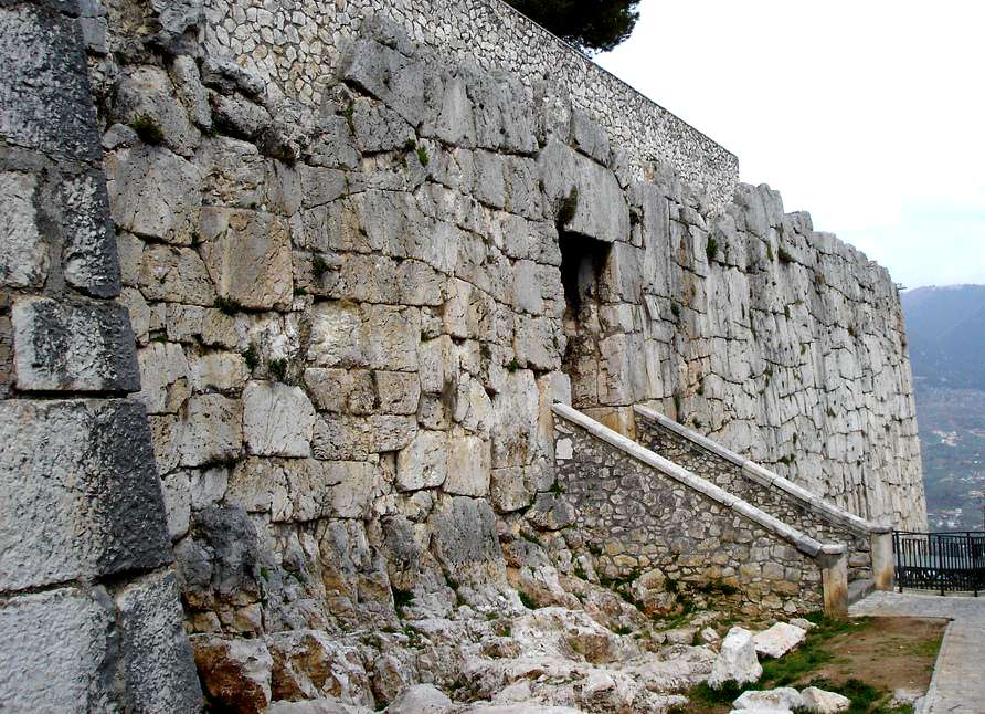
Fig. 1. The acropolis of Alatri: The south side with the main gate (the staircase is a 19th-century addition). Photograph © Giulio Magli
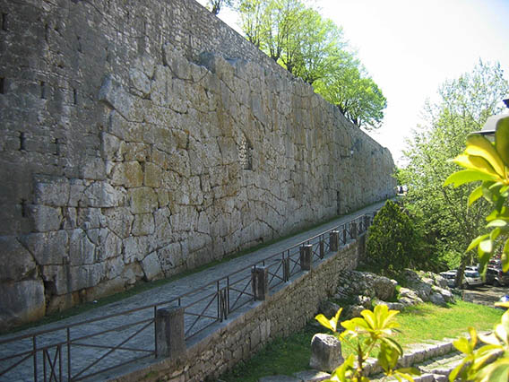
Fig. 2. The acropolis of Alatri: the north-west front with the postern gate. Photograph © Giulio Magli
Alatri cathedral stands within the acropolis. The lower courses of stone in its walls belong to an earlier building, possibly a temple, constructed using the polygonal technique. The northern wall contains a huge block measuring 2.5 × 2 × 1m, which was cut with nine corners and then joined to other eight blocks. Just behind this stone there is a natural fissure in the rocks, which might have been the foundation deposit (i.e., a pit, or a natural crevasse, where ritual objects and/or vegetables were buried at the act of the foundation of a town). This point is marked O in Fig. 3.
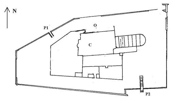
Fig. 3. Schematic map of Alatri acropolis. P1 - Postern gate; P2 - Main gate; C- Cathedral; O - Natural fissure in the rocks that might have been used as the foundation deposit of the town. After Magli (2006), fig. 2
History
Town of Alatri, Frosinone Province, Lazio Region, Italy.
Location
Latitude 41° 43′ 35″ N, longitude 13° 20′ 32″ E. Elevation 490m above mean sea level.
General description
Alatri is one of several towns in the ancient Latium Vetus—a wide area in central Italy broadly enclosed by the coast and the Apennines between Rome and Terracina—whose walls and buildings were constructed using the ‘polygonal’ technique, in which enormous stone blocks are cut in irregular shapes and perfectly fitted together without mortar. Alatri was built around a small hill and the acropolis (citadel) was placed on the hill, forming a sort of huge ‘geometric castle’ dominating the centre of the town.
Brief inventory
The acropolis has two entrances, a major gate (Porta Maggiore) with a 24-tonne lintel measuring 5 × 2 × 1.5m and a postern gate (Porta Minore) on the opposite side. There are no inscriptions: the only mark left by the builders is a symbol on the lintel of the postern gate composed of three phalli arranged so as to form a T-shaped (or cross-shaped) image. On the opposite side of the building, at ground level, are three huge niches (c. 2m high and 1m wide); they have no structural function and appear to have held statues.
Fig. 1. The acropolis of Alatri: The south side with the main gate (the staircase is a 19th-century addition). Photograph © Giulio Magli
Fig. 2. The acropolis of Alatri: the north-west front with the postern gate. Photograph © Giulio Magli
Alatri cathedral stands within the acropolis. The lower courses of stone in its walls belong to an earlier building, possibly a temple, constructed using the polygonal technique. The northern wall contains a huge block measuring 2.5 × 2 × 1m, which was cut with nine corners and then joined to other eight blocks. Just behind this stone there is a natural fissure in the rocks, which might have been the foundation deposit (i.e., a pit, or a natural crevasse, where ritual objects and/or vegetables were buried at the act of the foundation of a town). This point is marked O in Fig. 3.
Fig. 3. Schematic map of Alatri acropolis. P1 - Postern gate; P2 - Main gate; C- Cathedral; O - Natural fissure in the rocks that might have been used as the foundation deposit of the town. After Magli (2006), fig. 2
History
The acropolis has two entrances, a major gate (Porta Maggiore) with a 24-tonne lintel measuring 5 × 2 × 1.5m and a postern gate (Porta Minore) on the opposite side. There are no inscriptions: the only mark left by the builders is a symbol on the lintel of the postern gate composed of three phalli arranged so as to form a T-shaped (or cross-shaped) image. On the opposite side of the building, at ground level, are three huge niches (c. 2m high and 1m wide); they have no structural function and appear to have held statues.
Fig. 1. The acropolis of Alatri: The south side with the main gate (the staircase is a 19th-century addition). Photograph © Giulio Magli
Fig. 2. The acropolis of Alatri: the north-west front with the postern gate. Photograph © Giulio Magli
Alatri cathedral stands within the acropolis. The lower courses of stone in its walls belong to an earlier building, possibly a temple, constructed using the polygonal technique. The northern wall contains a huge block measuring 2.5 × 2 × 1m, which was cut with nine corners and then joined to other eight blocks. Just behind this stone there is a natural fissure in the rocks, which might have been the foundation deposit (i.e., a pit, or a natural crevasse, where ritual objects and/or vegetables were buried at the act of the foundation of a town). This point is marked O in Fig. 3.
Fig. 3. Schematic map of Alatri acropolis. P1 - Postern gate; P2 - Main gate; C- Cathedral; O - Natural fissure in the rocks that might have been used as the foundation deposit of the town. After Magli (2006), fig. 2